
Extended to 24 July 2027
In Thai
And before July 2027
This page explains what the rules say. It is not legal advice, and it cannot tell you what may be built on a specific plot. The Thai text is the only official version. For a particular building or plot, check with the local authorities (Pattaya City Hall inside the city) and a property lawyer.
Can Someone Build in Front of My Sea View?
It is one of the first questions people ask us when they look at a condo with a view of the sea, and it is a fair one. Pattaya keeps building, and a view is only worth paying for if it is still there in ten years.
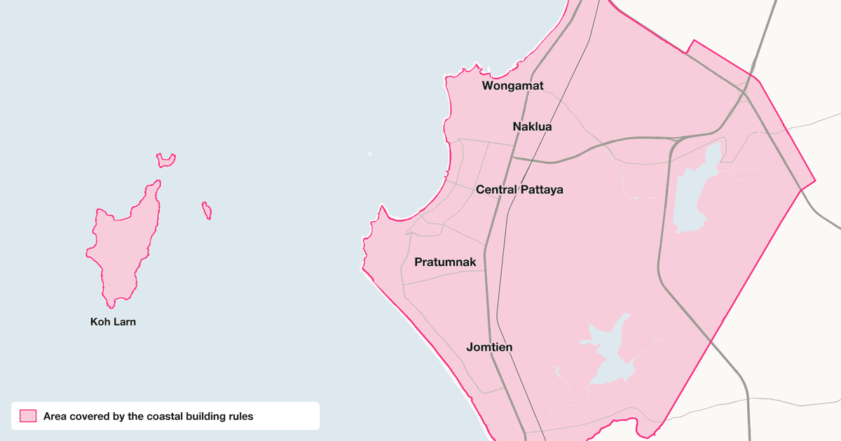
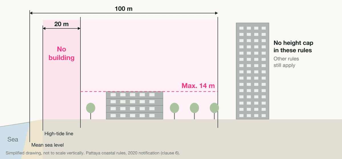
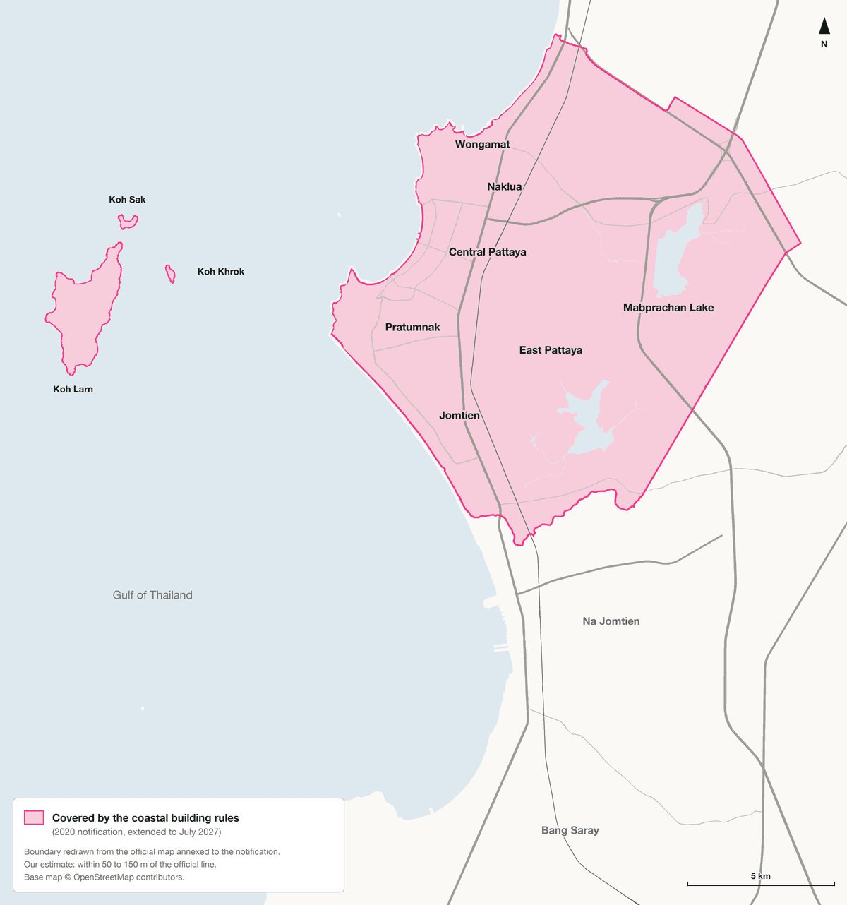
The short answer: close to the beach, the law is strict. Further back, it says much less. Inside the area these rules cover, which includes most of Pattaya (see the map below), here is the maximum height allowed by distance inland:
| Distance inland | Maximum height |
|---|---|
| 0 to 20 m | No building, apart from small public structures up to 4 m and state safety works |
| 20 to 100 m | 14 m, roughly four floors |
| Beyond 100 m | No height limit in these rules (on the mainland, on slopes under 20%) |
The 20 m is counted from the high-tide line. The 100 m is counted from the mean sea level line, a little further out on the beach, so the 14 m band ends a little less than 100 m inland from the high-tide line.
Two exceptions do not depend on the distance. On Koh Larn, Koh Sak and Koh Khrok, the limit is 9 m wherever building is allowed, and the 20 m strip along the shore applies there too. On hillsides, a slope of 20% to 35% allows only a detached house or single building up to 12 m on the mainland, and buildings up to 9 m on the islands. Above 35%, nothing can be built.
These rules come from a notification of the Ministry of Natural Resources and Environment, published in the Royal Gazette on 24 July 2020 and extended in 2025. The official text is in Thai, and we have not found an English translation. So we read the full text and its official map, and we explain here what they mean for someone buying in Pattaya.
All the Rules in Detail
| Where | What the rule says | Clause |
|---|---|---|
| First 20 m from the high-tide line | No building. The only exceptions are small utility or government structures (up to 4 m high, 24 m² in total and 6 m² per building), flood-protection works built by the state, and warning towers. The last two need the opinion of the provincial environmental committee. | 6 (1) |
| Within 100 m of the sea | Buildings up to 14 m high. At least 75% of the plot must stay open, and at least half of that open space must be green. | 6 (2) |
| Koh Larn, Koh Sak, Koh Khrok | Buildings up to 9 m high, with at least 75% of the plot open and at least half of that open space green. | 6 (3) |
| Slopes of 20% to 35% | On the mainland, only a detached house or a single building, up to 12 m high. On the islands, up to 9 m. On a plot of 100 square wah (400 m²) or more, each building covers at most 90 m² of ground and at least 70% of the plot stays open and permeable. On a smaller plot, at most 70 m², with at least 50% left open. | 6 (4) |
| Slopes above 35% | No building. | 6 (5) |
| Within 6 m of a river, canal or public water body | No building, measured from the natural bank, except public works for water transport or utilities, after review by the provincial committee. | 6 (6) |
How height is measured: from the ground, or from the road if the plot has been raised to road level or above, up to the highest point of the building. On sloping ground, it is measured from the lowest point of the building. For a gable or hip roof, it is measured to the top of the wall of the highest floor, not to the ridge (clause 7). A square wah is the Thai land unit of 4 m².
A Third Distance, 50 m, That Is Not About Height
The notification also uses 50 m, measured from the high-tide line. It does not change the height limits. It decides which environmental study a hotel, apartment building or condominium project must file before it can go ahead:
- Within 50 m of the high-tide line: a full environmental impact assessment (EIA). The text sets no minimum size (clause 11 (2)).
- More than 50 m from the high-tide line: a shorter initial assessment (IEE) for 30 to 79 rooms, or from 1,500 m² to just under 4,000 m² of floor area (clause 11 (1)). Larger projects are not listed in this clause; the national EIA rules, not covered here, also apply.
An approved study comes on top of the other rules in the notification, it does not replace them (clause 11). A condominium 30 m from the high-tide line needs a full EIA and still stops at 14 m.
Where the Rules Apply
The notification applies to the area drawn on the map annexed to it. We redrew that map on a current base map. It covers Pattaya from the north of Naklua, beyond Wongamat, to just south of Jomtien Beach, where it takes in the northern tip of Na Jomtien. Inland, it covers East Pattaya and Nong Prue and reaches into parts of Nong Pla Lai and Pong, around Mabprachan Lake. It also covers the three islands of Koh Larn, Koh Sak and Koh Khrok.
The rest of Na Jomtien, Bang Saray and the Sattahip coast are outside the mapped area, even though the notification’s title names Sattahip district. That does not mean anything goes there. Zoning and building-control rules apply everywhere. These particular coastal limits do not.
What This Means for a Sea View
- If the building is within 100 m of the sea, the land between it and the water is inside the band too. While these rules are in force, nothing new taller than 14 m can go up there, and nothing except small public structures in the first 20 m. A 14 m building can still block the view from a low floor.
- If the building is further back, the band only covers the strip nearest the beach. The land between your building and that strip, if it is on the mainland with a slope under 20%, has no height cap under this notification. What can be built there depends on zoning and building-control rules.
- What is already built stays (clause 18), although it cannot be altered or converted into a type of building the rules ban. The rules apply to new buildings, alterations and changes of use. A building that had its permit before 25 July 2020 can be finished under the earlier rules, but any change to that permit requested later follows the 2020 rules (clause 19).
- Some buildings near the beach are taller than 14 m. We have not found an official explanation that covers them. Only the permit file of a building can show which rules applied to it.
- On hillsides, the slope counts as much as the distance to the sea. On the slopes of Pratumnak Hill and on Koh Larn, the limits of 12 m and 9 m and the ban above 35% can decide what a plot can take.
If you are comparing condos along the beach, for example in Jomtien or on Pratumnak, the useful question is simple: is the land between the unit and the sea inside the 100 m band or not?
The Rules Run Until July 2027
The 2020 notification was valid for five years, until 24 July 2025. In April 2025 the ministry extended it by two years from 25 July 2025, so it now runs until 24 July 2027 (Royal Gazette, 28 April 2025). The extension gives one reason: the protection measures are still needed for a while longer.
What happens after July 2027 has not been announced. The ministry can extend the text again or replace it. For Phuket, a draft amendment to the equivalent notification was posted for public comment on the website of the Office of Natural Resources and Environmental Policy and Planning (ONEP) in June and August 2026. As of 8 October 2026, no draft for Pattaya was listed there. We check that page and will update this one when a draft appears.
The core limits are not new. The 2010 version already banned building in the first 20 m and capped heights at 14 m within 100 m of the sea. The 2020 text tightened the hillside rule, banning construction on slopes above 35% instead of 50%.
Other Things the Rules Ban
The same notification also decides what cannot be built next to you, which matters when you buy a house rather than a condo.
- No factories west of Sukhumvit Road. East of Sukhumvit, only the types of factory listed in the notification’s annex, with pollution-control equipment.
- No commercial livestock farms, except small ones of up to 200 m² that are at least 1 km from the coast and 30 m from public water sources and drinking-water wells, with waste treatment.
- No new crematoria, except to replace an existing one on the same site.
- No mining, and no commercial digging of sand, soil or gravel.
Zoning Is a Separate Layer
These coastal rules sit on top of zoning, which decides what kind of building a plot can take. Pattaya’s own city plan of 2015 is listed as cancelled by the Association of Siamese Architects. Since December 2019, land use in Chonburi follows the land-use plan of the Eastern Economic Corridor (EEC). According to the EEC Policy Committee announcement (Royal Gazette, 9 December 2019), as summarised by the Association of Siamese Architects, that plan serves as the city plan for the province until new city plans are drawn up.
LandsMaps, the Land Department’s free online map, shows the official appraised value of a titled plot and can show a zoning layer. Ask the city which plan that layer reflects before relying on it.
How to Check a Specific Building or Plot
- Ask for the permits. For an existing building, ask the seller or the juristic person for a copy of the building permit. For a new project, ask the developer for the building permit and the EIA approval. ONEP publishes the status of EIA reports on its website.
- Look at the plot in front of you. On LandsMaps, find the plot between your unit and the sea. Its zone colour, its slope and its distance from the beach give a first idea of which rules could apply to a new building there. Only the authorities can confirm it.
- Ask the local authority. Pattaya City Hall’s building control office can tell you what the rules allow on a plot inside the city. Outside it, for example in Nong Pla Lai or Pong, ask the local municipality.
- Have a lawyer check before you sign. A property lawyer can check the title, the permits and the rules that apply. We walk through the rest of the process in our step-by-step guide to buying property in Pattaya as a foreigner.
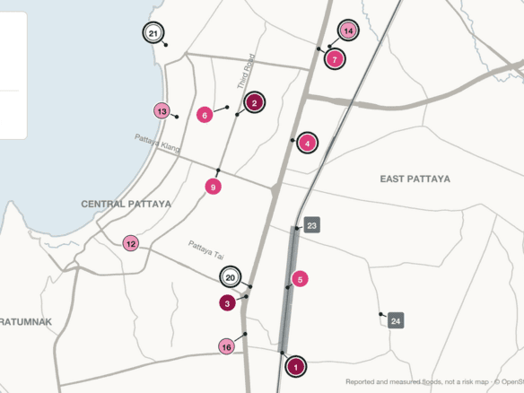
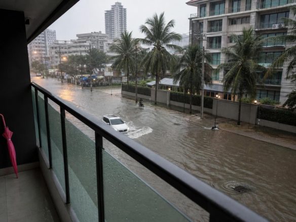
A sea view is one question. Water in the street is another: our Pattaya flood map records where flooding was reported or measured over the last three rainy seasons.
What This Page Can and Cannot Tell You
- It explains the notification in plain English. The Thai text in the Royal Gazette is the only official version, and it has more detail than we show here.
- The map boundary is approximate. It is redrawn from a 1:50,000 map, and we estimate it is within about 50 to 150 m of the official line.
- It does not cover every rule. Zoning, building control, fire safety and the national EIA rules also apply, inside and outside the mapped area.
- It cannot tell you what was permitted on a specific plot, or whether a given building follows the rules.
- The rules can change. The current text runs until 24 July 2027.
- It is not legal advice. For a decision about a property, speak to a property lawyer.
Using This Page
Can I reuse the map or the table? Yes. Please credit the Ministry of Natural Resources and Environment for the rules and OpenStreetMap contributors for the base map, and link to this page for the translation and the redrawn map.
Something here is wrong or out of date. Tell us through our contact page, with a link to the official text if you have one, and we will check it.
Sources
- Notification of the Ministry of Natural Resources and Environment on environmental protection areas and measures in Bang Lamung and Sattahip districts, Chonburi, 2020 (ประกาศกระทรวงทรัพยากรธรรมชาติและสิ่งแวดล้อม เรื่อง กำหนดเขตพื้นที่และมาตรการคุ้มครองสิ่งแวดล้อม ในบริเวณพื้นที่อำเภอบางละมุง และอำเภอสัตหีบ จังหวัดชลบุรี พ.ศ. 2563). Royal Gazette, volume 137, special section 170 Ng, 24 July 2020, with its annexed map. Thai text (PDF, ONEP).
- Notification extending the above by two years, 2025. Royal Gazette, volume 142, special section 177 Ng, page 35, 28 April 2025. Thai text (PDF, ONEP).
- The 2010 version of the notification, as summarised by the Association of Siamese Architects: asa.or.th (in Thai).
- List of comprehensive city plans in force and cancelled, Association of Siamese Architects: asa.or.th (in Thai), for the status of Pattaya’s 2015 city plan.
- EEC land-use plan, announcement of the EEC Policy Committee, Royal Gazette, 9 December 2019, as summarised by the Association of Siamese Architects: asa.or.th (in Thai).
- ONEP list of drafts open for public comment: onep.go.th (in Thai), checked on 8 October 2026.
- LandsMaps, Land Department: landsmaps.dol.go.th.
All dates are converted from the Thai Buddhist calendar: 2563 is 2020, 2568 is 2025 and 2570 is 2027.
If You Are Looking at a Specific Building
If you have a unit in mind, get in touch. We will look at what stands between it and the sea and which parts of these rules seem to matter for it, tell you when the honest answer is that nobody can say yet, and point you to the office or lawyer who can confirm it.