
Three rainy seasons
Mostly in Thai
Then once a year
This page records where flooding was reported or measured. It is not an official flood-risk map. It cannot tell you that a street stays dry, and a street that is missing here may simply never have been reported. It is also not advice to buy or avoid any area.
Which Streets Have Flooded?
Buyers often ask us about flooding after seeing the storm videos, and the honest answer used to be “it depends who you ask”. The city keeps a working list of its trouble spots. As far as we can find, it has never published that list as a document.
The information exists, but it is scattered. Most of it is in Thai: news reports written the morning after each storm, a draft road-closure plan the city presented at a meeting in September 2025, and a station-by-station table of rainfall and flood depths that the mayor posted on Facebook on 24 September 2026. We collected all three, translated them, and placed every location we could identify on one map.
The result covers three rainy seasons, from May 2024 to 24 September 2026, and 25 separate storms. We will update it after each rainy season.
The Map
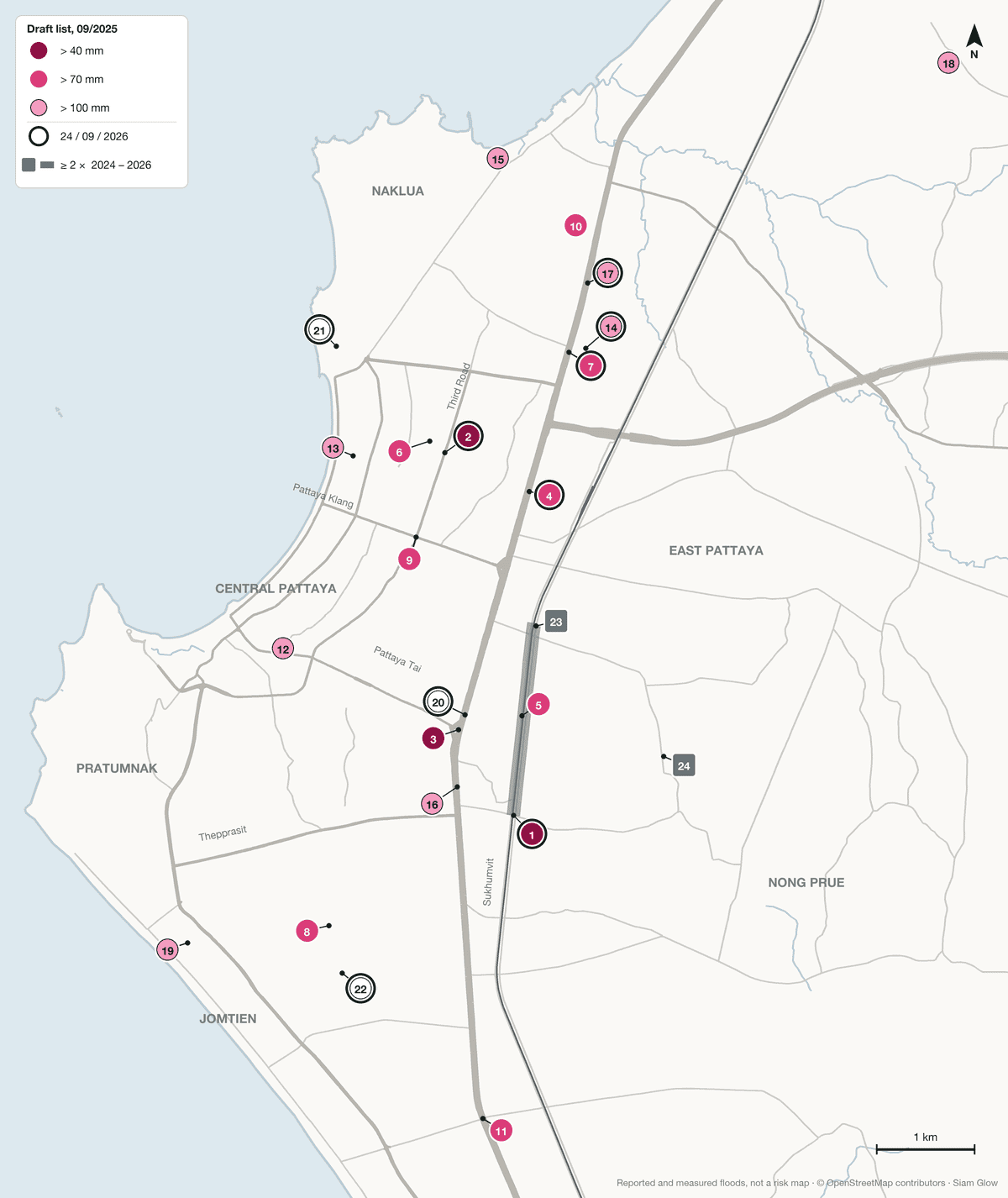
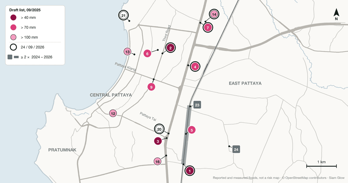
The numbers on the map match the table below. Under each location is its Thai name as the source gives it, which is what you would type into a Thai search engine or show to a taxi driver.
| No. | Location (Thai name as in the source) | Why it is on the map |
|---|---|---|
| 1 | Railway road at the Khao Talo junctionถ.เลียบทางรถไฟ แยกเขาตาโล | City list, stage 1 (over 40 mm). Measured on 24 Sep 2026: 100 cm over 500 m. The railway road corridor came up in 21 of 25 storms |
| 2 | Third Road at the Phaniat Chang junction (Moom Aroi)ถ.พัทยาสาย 3 แยกเพนียดช้าง (มุมอร่อย) | City list, stage 1 (over 40 mm). Measured on 24 Sep 2026: 100 cm over 800 m, for 7 h 22 min. Third Road came up in 18 of 25 storms |
| 3 | Sukhumvit Road at the South Pattaya junction (Highway Police)ถ.สุขุมวิท หน้า สภ.ทางหลวง | City list, stage 1 (over 40 mm). Sukhumvit around the South Pattaya junction came up in 17 of 25 storms |
| 4 | Mouth of Soi Sukhumvit-Pattaya 45ซ.สุขุมวิท 45 | City list, stage 2 (over 70 mm). Measured on 24 Sep 2026: 40 cm over 150 m |
| 5 | Railway road at the Wat Tham Samakkhi junctionถ.เลียบทางรถไฟ แยกวัดธรรมสามัคคี | City list, stage 2 (over 70 mm). Part of the railway road corridor |
| 6 | Phetchtrakul Road at the Hollywood junctionถ.เพ็ชรตระกูล แยกฮอลลีวูด | City list, stage 2 (over 70 mm). Homes flooded in Pacific Village, opposite Hollywood, on 24 Sep 2026 (city press release). Position approximate |
| 7 | Sukhumvit Road in front of Pattaya City School 4ถ.สุขุมวิท หน้า รร.เมืองพัทยา 4 | City list, stage 2 (over 70 mm). Measured on 24 Sep 2026: 25 cm over 100 m |
| 8 | Soi Thepprasit 7 and Soi Thepprasit 9ซ.เทพประสิทธิ์ 7 และ 9 | City list, stage 2 (over 70 mm). The Kung Ten junction on Soi 7 was reported flooded on 4 Jul 2026. Position approximate |
| 9 | Pattaya Klang Road at the Chumsai junction (Mae Wilai market)ถ.พัทยากลาง แยกชุมสาย ตลาดแม่วิไล | City list, stage 2 (over 70 mm) |
| 10 | Soi Hua Thungซ.หัวทุ่ง | City list, stage 2 (over 70 mm) |
| 11 | Sukhumvit Road at the Chaiyapruek junctionถ.สุขุมวิท ก่อนถึงแยกชัยพฤกษ์ | City list, stage 2 (over 70 mm) or stage 3 depending on the report |
| 12 | Soi Buakhao and Soi Taeng Moซ.บัวขาว และ ซ.แตงโม | City list, stage 3 (over 100 mm). Soi Buakhao was also reported flooded on 24 Sep 2026. Position approximate |
| 13 | Soi Pattaya 6/1ซ.พัทยา 6/1 | City list, stage 3 (over 100 mm) |
| 14 | Soi Wat Nong Yai (and Soi Nong Yai 2)ซ.วัดหนองใหญ่ | City list, stage 3 (over 100 mm). Measured nearby at “Nong Yai Soi 2” on 24 Sep 2026: 50 cm over 150 m. The Nong Yai Soi 2 intersection was also reported flooded on 10 Sep 2026 |
| 15 | Soi Naklua 10ซ.นาเกลือ 10 | City list, stage 3 (over 100 mm) |
| 16 | Mouth of Soi Sukhumvit-Pattaya 81ซ.สุขุมวิท 81 | City list, stage 3 (over 100 mm). On 24 Sep 2026 the Sukhumvit 81 station recorded 120 mm with no flooding entered |
| 17 | Mouth of Soi Sukhumvit-Pattaya 33ซ.สุขุมวิท 33 | City list, stage 3 (over 100 mm). Measured on 24 Sep 2026 at the “PSV + Sukhumvit 33” station: 20 cm over 100 m |
| 18 | Soi Nong Ket Yaiซ.หนองเกตุใหญ่ | City list, stage 3 (over 100 mm). Also reported on 16 Oct 2024. Position approximate |
| 19 | Soi Jomtien 5ซ.จอมเทียน / ซอยจอมเทียน 5 | City list, stage 3 (over 100 mm), as Soi Jomtien or Soi Jomtien 5 depending on the report |
| 20 | Mouth of Soi Sukhumvit-Pattaya 75สุขุมวิท 75 | Measured on 24 Sep 2026: 70 cm over 500 m |
| 21 | Soi Naklua 22นาเกลือ 22 | Measured on 24 Sep 2026: 50 cm over 150 m, for 8 h 46 min, the longest flood in the city’s table |
| 22 | Pattaya Youth Centre (station name)ศูนย์กีฬาเยาวชน | Measured on 24 Sep 2026 at the station the city names after the Youth Centre: 40 cm over 200 m. Position approximate |
| 23 | Railway road at Khao Noiถ.เลียบทางรถไฟ เขาน้อย | Part of the railway road corridor, which came up in 21 of 25 storms. Khao Noi itself is named in 8 of them. Position approximate |
| 24 | Soi Wat Boon Samphanซ.วัดบุญสัมพันธ์ | Reported in 3 storms: 16 Oct 2024, 10 Sep 2026 and 24 Sep 2026. Position approximate |
Some places came up in the reports but could not be placed with any confidence, so they are listed here rather than drawn on the map: Beach Road (4 storms), Pattaya Klang Road away from the Chumsai junction (3 storms), Pattaya Tai Road and Pattaya Sai 2 (2 storms each), Walking Street, Naklua Road, Dongtan Road in Jomtien and the Jomtien Beach area (1 storm each). The same goes for three points on the city’s list that we could not locate: Sukhumvit Road in front of the Thai Namthip company, the mouth of Soi Yensabai, and Saphan Yao, the long bridge.
What the City Measured on the Night of 23 to 24 September 2026
This is the most precise data we found, and it comes from the city itself. After the storm, Mayor Poramese Ngampichet posted a table of 25 rain readings: 24 at city stations and one from the Meteorological Department’s Pattaya station. For each one it gives the rainfall between 11:52 pm and 8:46 am, and where there was flooding, how deep, how wide and how long the water stood.
Rainfall ranged from 94 to 163 mm. In the same post, the mayor wrote that the city’s drainage works effectively up to 60 to 70 mm of rain. At 12 of the 24 city stations, the table records flooding:
| Station, as named by the city | Where | Rain (mm) | Depth | Width × length | Flooded for |
|---|---|---|---|---|---|
| แยกเพนียดช้าง (มุมอร่อย) | Third Road, Phaniat Chang junction | 114 | 100 cm | 50 m × 800 m | 7 h 22 min |
| เขาตาโล | Khao Talo | 112 | 100 cm | 50 m × 500 m | 5 h 11 min |
| สุขุมวิท 75 | Sukhumvit Road, Soi 75 | 106 | 70 cm | 50 m × 500 m | 1 h 40 min |
| นาเกลือ 22 | Soi Naklua 22 | 95 | 50 cm | 5 m × 150 m | 8 h 46 min |
| หนองใหญ่ ซ.2 | Soi Nong Yai 2 | 100 | 50 cm, then 20 cm | 5 m × 150 m, then 5 m × 50 m | 1 h 54 min, then 1 h 15 min |
| สุขุมวิท 45 | Sukhumvit Road, Soi 45 | 110 | 40 cm | 50 m × 150 m | 1 h 56 min |
| โรงบำบัดฯ | A treatment plant, location not given | 111 | 40 cm | 5 m × 800 m | 3 h 51 min |
| ศูนย์กีฬาเยาวชน | Station named after the Youth Centre | 135 | 40 cm | 6 m × 200 m | 1 h 36 min |
| หน้าเมืองพัทยา 4 | Sukhumvit Road, Pattaya City School 4 | 100 | 25 cm | 50 m × 100 m | 1 h 48 min |
| PSK | Station code, location not given | 137 | 20 cm | 15 m × 100 m | 40 min |
| PSV + สุขุมวิท 33 | Sukhumvit Road, Soi 33 | 100 | 20 cm | 5 m × 100 m | 3 h 32 min |
| CSO6/1 | Station code, location not given | 104 | 20 cm | 5 m × 1,000 m | About 3 h |
Source: table “สรุปสถานีที่มีฝนตกน้ำท่วม วันที่ 24 กันยายน 2569”, posted by Mayor Poramese Ngampichet on 24 September 2026 and shared by PR Pattaya, the city’s official page. Station names are the city’s own; the “Where” column is our reading of them.
Two things in this table deserve a mention. The longest flood of the night was not on one of the famous junctions but on Soi Naklua 22, where water stood for 8 hours 46 minutes, at 50 cm, on a stretch 150 m long. And at the other 12 city stations, the table records rain but leaves the flood columns blank. That includes the heaviest reading of the night, 163 mm at Khao Noi, where six pumps were running, and 132 mm at the Rajavarun station on Pratumnak Hill. A blank column means no flooding was recorded at that station. It does not tell you about the streets around it.
This is one night. It was a heavy one, well above the 60 to 70 mm the mayor says the drainage handles effectively, so it shows where water gathered under that stress. It does not show how often each place floods.
The City’s Own List, September 2025
On 15 September 2025, the Bang Lamung district chief chaired a meeting at Pattaya City Hall on flooding and traffic during heavy rain, with a deputy mayor, the city’s sanitation engineering bureau and the three local police stations. The city’s official PR page, PR Pattaya, reported the meeting on Facebook the next day. The list itself was reported by two Thai outlets, Ban Muang and OPT News.
What the city presented was a draft plan to close roads in three stages, depending on how much rain falls. Each stage adds locations to the one before. It is a traffic plan, not a flood survey, but it shows which locations the city expected to close first.
| Stage | Rain before closure | Locations added at this stage [map number] |
|---|---|---|
| Stage 1 | Over 40 mm, in about 30 minutes | Railway road at the Khao Talo junction [1] Third Road at the Phaniat Chang junction (Moom Aroi) [2] Sukhumvit Road at the South Pattaya junction (Highway Police) [3] |
| Stage 2 | Over 70 mm, in about 45 minutes | Mouth of Soi Sukhumvit-Pattaya 45 [4] Railway road at the Wat Tham Samakkhi junction [5] Phetchtrakul Road at the Hollywood junction [6] Sukhumvit Road in front of Pattaya City School 4 [7] Sukhumvit Road in front of the Thai Namthip company [not located] Soi Thepprasit 7 and Soi Thepprasit 9 [8] Pattaya Klang Road at the Chumsai junction (Mae Wilai market) [9] Soi Hua Thung [10] Sukhumvit Road at the Chaiyapruek junction [11] |
| Stage 3 | Over 100 mm, in about 60 minutes | Soi Buakhao and Soi Taeng Mo [12] Soi Pattaya 6/1 [13] Soi Wat Nong Yai (and Soi Nong Yai 2) [14] Soi Naklua 10 [15] Mouth of Soi Sukhumvit-Pattaya 81 [16] Mouth of Soi Yensabai [not located] Saphan Yao, the long bridge [not located] Mouth of Soi Sukhumvit-Pattaya 33 [17] Soi Nong Ket Yai [18] Soi Jomtien 5 [19] |
Translated from Ban Muang (17 September 2025) and OPT News. Both describe a draft, and we have not found a final version.
Officials do not agree with each other on how many flood points the city has, and it is worth knowing that before you quote any single figure. At the same meeting, the district chief said the city had gone from 22 flood points to between 3 and 6. A week earlier, during a visit by the Chonburi governor, the figure given was “more than 20, now 9” (OPT News). In July 2026 the mayor wrote of 20 chronic spots, more than half of them already upgraded (Bangkok Post). In September 2026 he put 9 points under 24-hour watch (Bangkok Biz News). The numbers describe different things at different dates, and none of them comes with a published list.
Every Flood We Found, May 2024 to September 2026
The table lists each storm that the press, or the city, reported as flooding named streets in Pattaya or Jomtien. Depths are what the reporters wrote, not measurements, and two outlets covering the same night sometimes give different figures, so we show both.
Three corridors dominate. The railway road on the east side, with the sois of Khao Talo and Khao Noi beside it, came up in 21 of the 25 storms. Third Road, mostly at the Phaniat Chang junction by the Moom Aroi restaurant, came up in 18. Sukhumvit Road around the South Pattaya junction came up in 17. Only one of the 25 storms, on Dongtan Road in Jomtien, touched none of the three. These counts show where floods were reported. Reporters go back to the main roads where traffic stops, so quieter streets are under-counted.
| Date | What was reported |
|---|---|
| 2024 rainy season | |
| 7 May 2024Morning storm, before the rainy season | Railway road from the soi behind Wat Tham Samakkhi towards Soi Khao Talo, closed to traffic at 9:23 amDepth reported: Not givenSources: Bangkok Biz News (Thai) |
| 21 May 2024On and off through the afternoon | Railway road between Soi Wat Tham Samakkhi and Soi Khao Talo; Sukhumvit Road, South Pattaya; Phaniat Chang and Moom Aroi junction. Part of Third Road collapsed near HollywoodDepth reported: 10 to 70 cmSources: The Pattaya News |
| 11 July 2024About 3 hours, morning | Sukhumvit Road; railway road from Soi Khao Talo towards Soi Khao Noi, where a car was submerged to its roofDepth reported: About 50 cm on Sukhumvit (Thai PBS). Nation, citing a Facebook post, wrote nearly 2 mSources: Thai PBS (Thai), Nation |
| 17 August 2024Over 1 hour from 7:30 am | Railway road between Soi Khao Noi and Soi Khao Talo; Sukhumvit Road, South Pattaya and at Soi 87; Beach Road; Soi Khao Noi; Soi Khao Talo. Water entered homes along the railway road and around Khao NoiDepth reported: 30 to 100 cm (Thairath); 30 to 50 cm on the railway road (Pattaya Mail)Sources: Thairath (Thai), Pattaya Mail |
| Night of 1 to 2 September 2024Heavy rain and strong gusts; several hours according to Thairath | Sukhumvit Road, South Pattaya; Third Road; railway road. Thairath also names Pattaya Klang Road and Beach RoadDepth reported: 10 to 80 cm (Dailynews); 70 to 80 cm (Thairath)Sources: Dailynews (Thai), Thairath (Thai) |
| Night of 2 to 3 September 2024About 3 hours | Third Road, where several cars were damaged; the highway section of Sukhumvit RoadDepth reported: Not givenSources: Thai PBS (Thai), Thai PBS World |
| 18 September 2024Over 1 hour, before dawn | Railway road from Khao Talo to Wat Tham Samakkhi; Sukhumvit Road from South Pattaya towards Central Pattaya; Third Road at the Phaniat Chang (Moom Aroi) junction; Beach Road; Pattaya Tai and Pattaya Klang roadsDepth reported: Over 90 cm at the worst point (Ch3 Plus, Nation); up to 90 cm (FM91)Sources: Ch3 Plus (Thai), FM91 (Thai), Nation |
| 6 October 2024About 2 hours, evening | Sukhumvit Road from North Pattaya to the Sawang Fa junction and before the South Pattaya lights; Third Road at the Moom Aroi junctionDepth reported: Not givenSources: The Pattaya News |
| 16 October 2024Over 1 hour | Railway road from Soi Khao Talo to Wat Tham Samakkhi, both sides; Soi Khao Talo; Soi Wat Boon Samphan; Sukhumvit Road, South Pattaya, both sides; Soi Wat Nong Ket YaiDepth reported: Up to about 70 cm, on the railway road and SukhumvitSources: Dailynews (Thai) |
| 14 November 2024Over 1 hour, evening | Soi Khao Noi; Soi Khao Talo; railway road; Sukhumvit Road, South Pattaya; Phaniat Chang (Moom Aroi) junctionDepth reported: 30 to 70 cmSources: Naewna (Thai) |
| 2025 rainy season | |
| 7 April 2025Nearly 1 hour from 2 pm, before the rainy season | North Pattaya at the Moom Aroi junction; Naklua RoadDepth reported: Too deep for small cars and motorbikesSources: Siam News via LINE Today (Thai), The Pattaya News |
| Night of 2 to 3 May 2025Over 3 hours | Third Road, flooded along its length; railway road towards Khao Talo. Cars and motorbikes submergedDepth reported: Not givenSources: Nation, Pattaya Mail, The Pattaya News |
| 14 May 2025Morning | Sukhumvit Road in front of the highway office before South Pattaya; Moom Aroi junction on Third Road; railway road near Wat Tham SamakkhiDepth reported: Not givenSources: Khaosod English (X) |
| 21 May 2025Heavy downpour, morning | Dongtan Road, Jomtien, described as unusual for that roadDepth reported: Not givenSources: Pattaya Mail |
| 4 June 2025Over 1 hour, evening | Railway road at Khao Talo and on both sides of Wat Tham Samakkhi; Sukhumvit Road, South Pattaya; Third Road at the Phaniat Chang (Moom Aroi) junctionDepth reported: 10 to 70 cmSources: Dailynews (Thai), FM91 (Thai) |
| 20 June 2025Under 1 hour, from 11 pm | Railway road into Soi Khao Talo; cars and motorbikes submergedDepth reported: Not givenSources: Siam News via LINE Today (Thai) |
| 1 July 2025Over 2 hours, evening | Railway road; Third Road at the Phaniat Chang (Moom Aroi) junction; Sukhumvit Road, South Pattaya, in front of the Highway Police station and near the Central Pattaya underpassDepth reported: 20 to 70 cmSources: Naewna (Thai), Pattaya Mail, The Pattaya News |
| 7 September 2025Over 1 hour from about 9 to 10 pm; about 50 mm measured, according to OPT News | Soi Khao Talo; Soi Khao Noi; railway road from Khao Talo towards Wat Tham Samakkhi; Sukhumvit Road, South Pattaya; Third Road at the Phaniat Chang junction. A village behind the Floating Market was still flooded the next morning because the cables of its pumps had been stolenDepth reported: 50 to 80 cm (Thairath); 10 to 50 cm (Pattaya Mail)Sources: Thairath (Thai), MGR Online (Thai), OPT News (Thai), Pattaya Mail |
| 13 October 2025Over 1 hour from 1 pm | Third Road at the Phaniat Chang junction; Sukhumvit Road at Soi Ha Thanwa; Soi Khao NoiDepth reported: 50 to 60 cmSources: MGR Online (Thai), PPTV (Thai), The Pattaya News |
| 2026 rainy season | |
| 14 May 2026Over 1 hour, after 1:30 am | Soi Khao Noi; Soi Khao Talo; railway road behind Wat Tham Samakkhi and towards Khao Talo; Sukhumvit Road, South Pattaya; Third RoadDepth reported: Not givenSources: TrueID (Thai), 4forcenews (Thai), The Pattaya News |
| 4 July 2026From the morning | Sukhumvit Road at the South Pattaya junction; the railway crossing behind Wat Tham Samakkhi; Third Road at the Moom Aroi junction, closed to all vehicles; the Kung Ten junction on Soi Thepprasit 7. Separately, the city said in early July that several points along Jomtien Beach had flooded after the recent heavy rain; it found about 90 cm of silt in drainage pipes about 2 m deep and ordered them cleared within three daysDepth reported: About shin-deep at the South Pattaya junctionSources: Pattaya City enforcement unit, เทศกิจพัทยา (Facebook), 4forcenews (Thai), Ban Muang (Thai), The Pattaya News |
| 23 July 2026Over 1 hour, from about 5 am | Railway road from Soi Khao Talo to Soi Khao Noi, closed with steel barriersDepth reported: 10 to 70 cmSources: Bangkok Post |
| Night of 10 to 11 September 2026Over 2 hours, with strong wind | Railway road from Soi Khao Talo to Soi Wat Tham Samakkhi, both sides; Soi Wat Boon Samphan; Soi Khao Talo; Third Road at the Phaniat Chang (Moom Aroi) junction; Sukhumvit Road, South Pattaya. Pattaya Mail adds Sukhumvit Road in front of Lotus South Pattaya, Sattahip-bound side, and the Nong Yai Soi 2 intersection, and reports water entering some homesDepth reported: 10 to 60 cmSources: MGR Online (Thai), Pattaya Mail |
| 23 September 2026Heavy and continuous from 12:30 pm | Third Road at Moom Aroi, closed; Sukhumvit Road at the Pattaya highway section, both directions; railway road at Wat Tham Samakkhi, closed; Soi 4 of Pattaya Sai 2 (Second Road), too deep for any vehicleDepth reported: 30 cm to almost 1 mSources: Thairath (Thai), MGR Online (Thai), Bangkok Biz News (Thai), Pattaya Mail, Pattaya City enforcement unit, เทศกิจพัทยา (Facebook) |
| Night of 23 to 24 September 2026From about 11 pm, over 1 hour of very heavy rain and some 5 hours in all. The city measured 94 to 163 mm | Third Road; Pattaya Klang Road; Soi Buakhao; Sukhumvit Road, north and south; the railway road on both sides, between Khao Noi and Khao Talo; Pattaya Tai Road; Beach Road; Walking Street; Soi Wat Boon Samphan; Pattaya Sai 2; Phetchtrakul Road. Water entered homes in Pacific Village, opposite Hollywood, where two walls collapsedDepth reported: 50 cm to 1 m in the press; the city measured 20 to 100 cm at 12 of its 24 stations (table above)Sources: Pattaya City press release no. 1,000/69 (Thai), Thairath (Thai), Dailynews (Thai), Thai PBS (Thai), Nation |
Neighbourhood by Neighbourhood
Central Pattaya
Most of the recurring points in Central Pattaya sit on Third Road and the streets that cross it. Third Road came up in 18 of the 25 storms, most often at the Phaniat Chang junction by the Moom Aroi restaurant. That junction is in the city’s first stage, and on 24 September 2026 the city measured 100 cm there over 800 m, for more than seven hours. Pattaya Klang Road at the Chumsai junction, Soi Buakhao with Soi Taeng Mo, and Soi Pattaya 6/1 are on the city’s list at the higher rainfall stages. Beach Road and Pattaya Klang Road appear in several reports without a precise location.
What the sources do not say: which buildings along these roads took water inside. Reports describe roads and passing traffic. When homes are mentioned, it is as a general remark (“water entered homes along the road”), without addresses.
East Pattaya and Nong Prue
This is where the record is densest. The railway road between Soi Khao Talo, Wat Tham Samakkhi and Khao Noi is named in more storms than any other place in the city, and the Khao Talo junction is in the city’s first stage. On 24 September 2026 the city measured 100 cm there over 500 m. Soi Wat Boon Samphan came up in three storms. Further north, Phetchtrakul Road at the Hollywood junction is on the city’s list, and on 24 September 2026 water entered homes in Pacific Village opposite Hollywood. According to the city’s press release, the village sits in a natural basin, neighbouring land that used to take the water has been filled and raised, and the collapse of two walls let water from Third Road pour in.
A drainage connection for the railway road and a pump sump near Phaniat Chang 2 are listed under “Drainage Works That Could Change the Picture” below.
What the sources do not say: much about the housing estates away from the main roads, which reporters rarely reach at night. The absence of a report there is weak evidence either way.
Jomtien
The record for Jomtien is thin. Pattaya Mail reported flooding on Dongtan Road on 21 May 2025, describing it as unusual for that road. In early July 2026, after flooding at several points along Jomtien Beach, the city found about 90 cm of silt in drainage pipes about 2 m deep there and ordered them cleared within three days. Soi Jomtien (or Soi Jomtien 5), Soi Thepprasit 7 and 9, and Sukhumvit at the Chaiyapruek junction are on the city’s list at the higher stages. On 24 September 2026 the city measured 40 cm at the station named after the Pattaya Youth Centre, whose exact position it does not publish.
Two drainage projects in Jomtien are listed with the others under “Drainage Works That Could Change the Picture” below.
What the sources do not say: anything about flooding inside condominium buildings in Jomtien. We found no such report.
Pratumnak
We found no report of street flooding on Pratumnak Hill between May 2024 and September 2026, in Thai or in English. On 24 September 2026, the city’s Rajavarun station on the hill recorded 132 mm of rain with its flood columns blank. The foot of the hill is close to streets that do appear in the record: Walking Street was reported flooded on 24 September 2026, Pattaya Tai Road in 2 storms and Beach Road in 4. The routes from Pratumnak to Sukhumvit Road also pass the South Pattaya junction.
What the sources do not say: that Pratumnak cannot flood. No report is not the same as no water.
Naklua and Wongamat
For Naklua, the press record is short: Naklua Road flooded on 7 April 2025, before the rainy season, deep enough to stop small cars. The city’s list adds Soi Naklua 10 at the highest rainfall stage. It also names Saphan Yao, the long bridge, which we could not place on the map. The city’s measurements add detail the press does not give: on 24 September 2026, Soi Naklua 22 had the longest flood of any station, 8 hours 46 minutes at 50 cm.
What the sources do not say: anything specific about Wongamat. We found no report of a specific flood there. Wongamat appears only in a general list of areas under watch, published by Pattaya Mail in May 2026.
What You Can Check Before You Buy
A map of reported floods tells you where to look more closely. It does not tell you about a specific building. These are the checks that do, most of which cost nothing:
- Look at the approach, not only the building. Trace the roads you would drive every day and compare them with the numbered points on the map. Then ask how residents got in and out of the building during the storms listed above.
- Ask the juristic person about the last big storm. Pick a recent date from the table above, so the question is specific. Did water reach the car park, the lift pits, the electrical room? How long before the building was fully back to normal?
- Check where the parking is. Basement and ground-level parking is usually the first place water reaches. Ask whether the building has pumps, when they were last serviced, and who runs them at night.
- Compare the entrance with the street. A building whose ground floor sits well above the soi has more margin than one that sits level with it. A building surveyor can tell you more.
- Visit in the rain. Between May and October you have a fair chance of seeing a real storm. One wet visit tells you more than any listing photo.
- Read the insurance, not the assumption. Ask for the building’s policy summary and check what flood cover it includes. For your own unit and contents, a licensed broker can confirm in writing what is covered.
We went through these checks in more detail, with the insurance side, in our article on what buyers should actually check about flooding in Pattaya.
Drainage Works That Could Change the Picture
The record above describes the drainage as it was. Several projects, finished or under way, could change it, so we note them here and will check the next rainy season against them.
- Jomtien Beach Road: a drainage line of about 3.5 km, completed in December 2025 (Pattaya Mail). Several points along Jomtien Beach still flooded in early July 2026, and the city then found its pipes there partly filled with silt.
- Soi Thepprasit 9 to Jomtien Second Road: a new large drain, handed over in April 2026 (Pattaya Mail).
- Railway road, East Pattaya: a project to connect the drainage of the east side of the railway road, budgeted at 30 million baht in the city’s project register (project P-67-0369, budget year 2567 going by the project code).
- Pump sumps: drains with pumping pits on a soi beside Phaniat Chang 2, a soi linking to Soi Thepprasit 17, and Soi Sukhumvit-Pattaya 34, budgeted in the register (projects P-68-0026 to P-68-0028, budget year 2568 going by the project code).
- A large tunnel: the mayor wrote on 24 September 2026 that a 3.5 m water tunnel starts this budget year and will take four years.
A project in the register shows the city plans the work. It does not tell you whether or when it was finished, or how well it works in a real storm.
What This Page Can and Cannot Tell You
- It shows where flooding was reported or measured. Reporters go back to the places they already know, usually where cars stall on main roads. Quieter sois and private estates are under-reported, so the map leans towards the busy corridors.
- It is about streets, not buildings. A flooded road outside does not mean water inside a unit, and a dry road does not rule out a flooded car park.
- Positions are approximate. The sources name junctions and sois, not coordinates, so a marker can be a hundred metres or more from where the water actually stood.
- Depths are mostly estimates. Only the city’s table of 24 September 2026 gives measured depths. Everything else is a reporter’s reading of the water against cars and kerbs.
- It does not forecast anything. Drainage works are under way, and the mayor says a large 3.5 m tunnel is due to start this budget year and take four years. The record could look different in two years, better or worse.
- It is not official. The city’s list was a draft, and this compilation is ours. For questions about a specific address, contact Pattaya City directly. Its 24-hour hotline for flooding and sandbags is 1337, according to its press release of 24 September 2026.
Using This Page
Can I reuse the map or the tables? Yes. Please credit Pattaya City for its measurements, Ban Muang and OPT News for the draft list, OpenStreetMap contributors for the base map, and link to this page for the compilation and translation. Each storm is linked to its sources in the table, and most other sources are linked in the text, so you can go back to the originals.
You missed a flood on my street. Quite possibly. Send us the date and a link to a report or a dated photo through our contact page and we will check it for the next update. We only add a location once it meets the rule set out under Sources and Method.
Why does the map stop at 24 September 2026? That is when we compiled it, in the middle of a rainy week. We will update it once the 2026 rainy season is over.
Sources and Method
We searched Thai sources first, because that is where the detail is. Official documents only show up when you search with the Buddhist Era year, 2567 to 2569 for 2024 to 2026, and we converted every date to the Gregorian calendar. A storm is in the table when the city or at least one identifiable news outlet reported flooding on named streets; storms we only saw on social media are left out. A location is on the map only if it is on the city’s draft list, was measured by the city, or was reported in at least two different storms.
This page is a factual record, not a flood-risk assessment or advice about any property or area. For a specific building, speak to the juristic person, a building surveyor and, for insurance, a licensed broker.
If You Are Looking at a Specific Building
We are in Pattaya through every rainy season, and we would rather tell you what we have seen on a street than let you judge it from a photo taken in January. If you have a building or a soi in mind, get in touch and we will tell you what we know about it, including when that is not much.